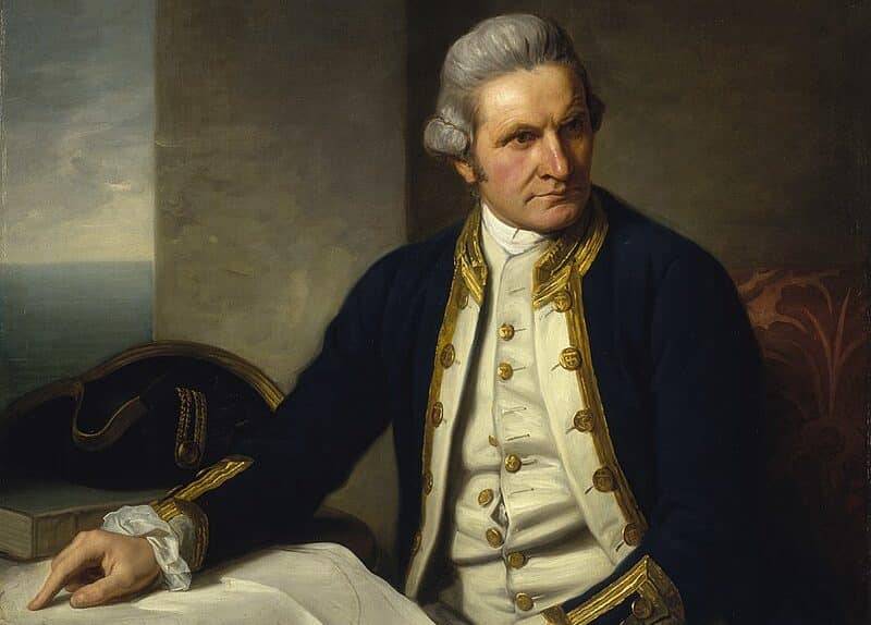
Captain James Cook was a prolific explorer in the late 18th century. He discovered and mapped out Australia, New Zealand, and the Hawaiian Islands. He would leave a lasting legacy for future explorers of the British Empire.

He circumnavigated the globe twice and died on his third circumnavigation. His final voyage occurred during the American Revolutionary War.
Early Life
Captain James Cook was born on November 7, 1728, in the village of Marton in Yorkshire. He was the second of eight children to his father of the same name, James Cook Sr., and Grace Pace.
In 1736, his family moved to Airley Holme farm at Great Ayton, where his father's employer, Thomas Skottowe, paid for him to attend the local school. After 5 years, he began to work for his father, and despite not receiving all of his education, he became well-versed in mathematics, astronomy, and charting.
Cook would get his first taste of the sea when he traveled to the port town of Whitby and was introduced to John and Henry Walker. The Walkers were prominent local shipowners in the coal trade. Cook became an apprentice in their small fleet. During his apprenticeship, Cook applied himself to the study of algebra, geometry, trigonometry, navigation, and astronomy.
After his three-year apprenticeship, Cook began working on trading ships in the Baltic Sea and eventually rose to the rank of a mate. However, he decided to restart his career in the military, where he knew it would take less time to become captain of his own ship. He began his military career around the time of the Seven Years' War (French and Indian War in America).
Cook married Elizabeth Batts, and the couple had six children. Each of whom would die before they had children of their own.
Royal Navy Career
During the Seven Years' War, Cook served in North America as master aboard the fourth-rate Navy vessel HMS Pembroke. With others in Pembroke's crew, he took part in the major amphibious assault that captured the Fortress of Louisbourg from the French in 1758 and in the siege of Quebec City in 1759.
Throughout his service, he demonstrated a talent for surveying and cartography and was responsible for mapping much of the entrance to the Saint Lawrence River during the siege, thus allowing General Wolfe to make his famous stealth attack during the 1759 Battle of the Plains of Abraham.
Cook's surveying ability was also put to use in mapping the jagged coast of Newfoundland in the 1760s aboard HMS Grenville. He surveyed the northwest stretch in 1763 and 1764, the south coast between the Burin Peninsula and Cape Ray in 1765 and 1766, and the west coast in 1767.
At this time, Cook employed local pilots to point out the "rocks and hidden dangers" along the south and west coasts. During the 1765 season, four pilots were engaged at a daily pay of 4 shillings each: John Beck for the coast west of "Great St Lawrence," Morgan Snook for Fortune Bay, John Dawson for Connaigre and Hermitage Bay, and John Peck for the "Bay of Despair."
While in Newfoundland, Cook also conducted astronomical observations, in particular of the eclipse of the sun on 5 August 1766. By obtaining an accurate estimate of the time of the start and finish of the eclipse and comparing these with the timings at a known position in England, it was possible to calculate the longitude of the observation site in Newfoundland. This result was communicated to the Royal Society in 1767.
His five seasons in Newfoundland produced the first large-scale and accurate maps of the island's coasts and were the first scientific, large-scale, hydrographic surveys to use precise triangulation to establish land outlines.
They also gave Cook his mastery of practical surveying, achieved under often adverse conditions, and brought him to the attention of the Admiralty and Royal Society at a crucial moment both in his career and in the direction of British overseas discovery. Cook's maps were used in the 20th century, with copies being referenced by those sailing Newfoundland's waters for 200 years.
First Voyage
On May 25, 1768, after years of service and accomplishments, the Admiralty commissioned Cook to command a scientific voyage to the Pacific Ocean. The purpose of this voyage was to record the transit of Venus across the Sun, which would help determine the distance of the Earth from the Sun.
Cook, at age 39, was promoted to lieutenant to grant him sufficient status to take the command. For its part, the Royal Society agreed that Cook would receive a one hundred guinea gratuity in addition to his Naval pay.
During this voyage, he would navigate through the Polynesian Islands, make very accurate maps, and then become the first European to make contact with the Eastern coast of Australia. He also discovered that New Zealand was not attached to Australia.
His voyage was delayed seven weeks when his ship ran aground at the Great Barrier Reef.
He returned to England via Batavia, where many in his crew succumbed to malaria, and then the Cape of Good Hope, arriving at the island of Saint Helena on 30 April 1771. The ship finally returned to England on 12 July 1771, anchoring in The Downs, with Cook going to Deal.
Second Voyage
Cook was promoted to commander after his first voyage and was commissioned for a second voyage.
The purpose of the second voyage was to search for the hypothetical Terra Australis, which was believed to be a large southern continent.
Cook commanded HMS Resolution on this voyage, while Tobias Furneaux commanded its companion ship, HMS Adventure. Cook's expedition circumnavigated the globe at an extreme southern latitude, becoming one of the first to cross the Antarctic Circle on 17 January 1773.
In the Antarctic fog, Resolution and Adventure became separated. Furneaux made his way to New Zealand, where he lost some of his men during an encounter with Māori, and eventually sailed back to Britain, while Cook continued to explore the Antarctic, reaching 71°10'S on 31 January 1774.
Captain James Cook returned to New Zealand in 1774 and landed at Friendly Islands, Easter Island, Norfolk Island, New Caledonia, and Vanuatu.
Before returning to England, Cook made a final sweep across the South Atlantic from Cape Horn and surveyed, mapped, and took possession for Britain of South Georgia, which had been explored by the English merchant Anthony de la Roché in 1675.
Cook also discovered and named Clerke Rocks and the South Sandwich Islands ("Sandwich Land"). He then turned north to South Africa and, from there, continued back to England.
His reports upon his return home put to rest the popular myth of Terra Australis.
Upon his return to England after his second voyage, Cook became well-known throughout the country, and his fame spread. His discoveries, maps, and methods would be revered throughout the world.
Third Voyage
Captain James Cook's third voyage had two goals.
The first goal was to return Omai to Tahiti. Omai had sailed with Cook during the second voyage after he resupplied in Tahiti.
The second goal and the primary goal that most did not know about was to search for the Northwest Passage. This passage had been searched by many explorers of the past.
After dropping Omai at Tahiti, Cook traveled north and, in 1778, became the first European to begin formal contact with the Hawaiian Islands.
After his initial landfall in January 1778 at Waimea harbor, Kauai, Cook named the archipelago the "Sandwich Islands" after the fourth Earl of Sandwich, the acting First Lord of the Admiralty.
Cook left the Sandwich Islands and sailed north and then northeast to explore the west coast of North America. He proceeded further north than the Spanish settlements in Alta, California, and off the coast of Oregon. H
He unknowingly sailed past the Strait of Juan de Fuca and entered Nootka Sound (named after the Nootka tribe) on Vancouver Island. Here, he anchored near the village of Yuquot, which was the homeland of Native Americans. Cook and the Yuquot Indians had a friendly but tenuous relationship.
After leaving Nootka Sound, Cook explored and mapped the coast all the way to the Bering Strait, on the way to identifying what came to be known as Cook Inlet in Alaska. In a single visit, Cook charted the majority of the North American northwest coastline on world maps for the first time, determined the extent of Alaska, and closed the gaps in Russian (from the west) and Spanish (from the south) exploratory probes of the northern limits of the Pacific.
Cook continued north but was blocked by ice and was growing very frustrated. He then turned his ship south and headed back to the Hawaiian Islands.
Upon Cook's return to Hawaii, the natives were in the middle of celebrations. Due to various reasons, Cook and his crew were deified by the Hawaiians as the reincarnation of their god, Lono. Cook and his crew stayed in Hawaii and then left after they had resupplied.
Death
Shortly after leaving Hawaii Island, however, Resolution's foremast broke, so the ships returned to Kealakekua Bay for repairs.
Tensions rose, and a number of quarrels broke out between the Europeans and Hawaiians at Kealakekua Bay. An unknown group of Hawaiians took one of Captain James Cook's small boats. The evening when the cutter was taken, the people had become "insolent" even with threats to fire upon them. Cook attempted to kidnap and ransom the King of Hawaii, Kalaniʻōpuʻu.
The following day, 14 February 1779, Cook marched through the village to retrieve the king. Cook took the king by his own hand and led him willingly away. One of Kalaniʻōpuʻu's favorite wives, Kanekapolei, and two chiefs approached the group as they were heading to boats. They pleaded with the king not to go.
An old kahuna (priest), chanting rapidly while holding out a coconut, attempted to distract Cook and his men as a large crowd began to form at the shore. The king began to understand that Cook was his enemy.
As Cook turned his back to help launch the boats, he was struck on the head by the villagers and then stabbed to death as he fell on his face in the surf. He was first struck on the head with a club by a chief named Kalaimanokahoʻowaha or Kanaʻina and then stabbed by one of the king's attendants, Nuaa.
The Hawaiians carried his body away towards the back of the town, still visible to the ship through their spyglass. Four marines, Corporal James Thomas, Private Theophilus Hinks, Private Thomas Fatchett, and Private John Allen, were also killed, and two others were wounded in the violent attack.
Captain James Cook is considered the greatest English Explorer. His legacy is what he gave to the scientific and navigation communities. Also, his discovery of the Hawaiian Islands, Australia, and New Zealand were important discoveries that would help the British expand their empire.
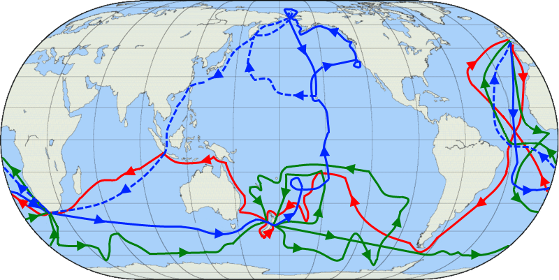
Below is a map of each of Cook's voyages. The first voyage is in red, the second is in green, and the third is blue.

